
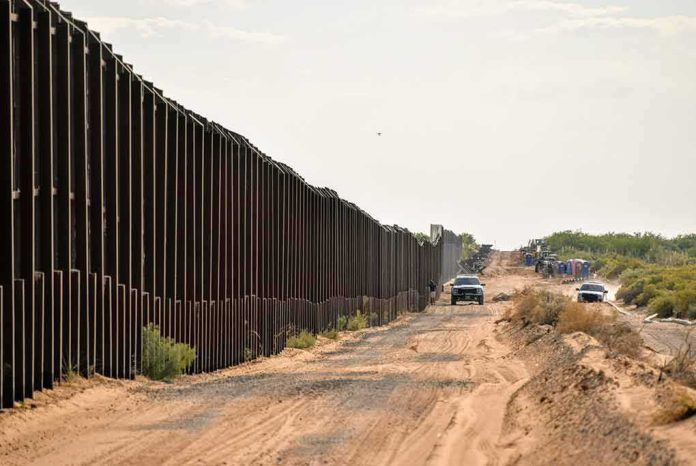
What decided the first round of the Tohono O’odham border-wall fight was not a referendum on sovereignty, but the law’s exacting standards for emergency relief and a century-old federal land strip along the border that the court read as authorizing construction without tribal consent.
At a Glance
- A federal judge denied the Tohono O’odham Nation’s request for a preliminary injunction to halt 62 miles of border wall activity along its reservation boundary.
- The ruling turned on the tribe’s failure—at this early stage—to show that wall work would unlawfully alter reservation boundaries or constitute trespass.
- The government’s authority case relied on the Roosevelt Reservation, a 60‑foot swath of public land along the border first reserved in 1907.
- Injunction standards are steep: the tribe must still litigate its core claims on the merits, where the evidence record will be fuller and the legal questions sharper.
What the court actually decided—and what it did not
U.S. District Judge Richard Leon refused to block the administration from advancing plans to construct new barrier segments across the Nation’s southern boundary. In plain terms, the court did not greenlight every aspect of the project; it refused an “extraordinary remedy” at the outset because the plaintiffs had not carried their burden to show a likelihood of success on two key theories and irreparable harm that could not be addressed later. According to the court’s public reasoning as reported from the bench and in subsequent coverage, the tribe had not established that a wall would change reservation boundaries without Congress, nor that the planned work constituted trespass on tribal land at this stage.
Preliminary injunctions turn on probability, not finality. The denial means the project is not frozen by court order; it does not resolve—one way or the other—the underlying claims that construction is unlawful. Those claims continue through briefing, evidence development, and potentially appeal.
The legal clash: boundaries, trespass, and a 1907 land strip
The Tohono O’odham Nation’s complaint anchors on two propositions. First, only Congress can diminish reservation boundaries; any executive action that alters those lines is ultra vires—beyond lawful authority. The filing expressly cites 25 U.S.C. § 398d, which the Nation reads as prohibiting boundary changes by administrative action. Second, the tribe pleads trespass, arguing that the government and its contractors would enter, occupy, or construct on tribal property without lawful right. These are not rhetorical talking points; they are pled causes of action aimed at drawing a bright jurisdictional line around the reservation.
The government counters with a different bright line: the Roosevelt Reservation, a 60‑foot strip of public land hugging the international boundary dating to Theodore Roosevelt’s 1907 proclamation. If the wall can be sited within that federal strip, the argument goes, there is no boundary diminishment and no trespass—construction occurs on federal land adjacent to, not on, the reservation. In denying the injunction, Judge Leon emphasized that building “adjacent” to a reservation does not inherently diminish its legal boundaries and that the record did not show a cognizable trespass theory likely to succeed. Reporting on the ruling further notes the court’s reliance on the Roosevelt Reservation as the operative federal property interest authorizing construction within that corridor.
Injunction standards are unforgiving by design
Why does this matter procedurally? Because preliminary injunctions demand a strong showing on four factors: likelihood of success on the merits, irreparable harm, balance of equities, and public interest. Courts treat them as an extraordinary stopgap reserved for clear cases. In border infrastructure disputes, that threshold has often been dispositive at the outset: tribes and local governments may raise weighty sovereignty or environmental concerns, but unless those translate into a high-probability legal violation tied to a specific situs (on whose land, under what title, pursuant to which statute), courts tend to defer to ongoing federal projects during early litigation.
The Tohono O’odham suit is consistent with that pattern. The Nation’s boundary-change claim turns on statutory interpretation and the precise alignment of any construction footprint relative to tribal title. The trespass claim likewise rises or falls on where boots and equipment would operate and whether any easements or federal enclaves reach those spots. At the emergency stage, ambiguity usually cuts against an injunction.
How we got here: the mix of sovereignty, security, and statutory authority
This case sits at the intersection of three recurring authorities. First, the plenary power of Congress over Indian affairs and the Supreme Court’s canon that only Congress may diminish reservation boundaries. Second, the Executive’s authority to manage federal lands—here, the Roosevelt Reservation’s narrow, contiguous strip along the border. Third, the immigration and border-security powers Congress has delegated to the Department of Homeland Security, which successive administrations have invoked to plan and build barriers, roads, and surveillance infrastructure along the line.
The friction is practical as much as doctrinal. Tribes with communities and sacred sites near the boundary experience adjacent construction as an encroachment—regardless of survey lines—because walls and patrol infrastructure can sever traditional travel routes, disrupt ceremonies, and endanger cultural or environmental resources. Federal agencies, by contrast, frame the same projects as sited on distinct federal property with statutory cover; they emphasize coordination with tribes and mitigation measures, but deny any tribal “veto” over border security siting decisions. When the dispute crystallizes in court, judges often ask the dispositive question first: whose land, exactly, and which statute governs the precise strip at issue?
Competing readings of the Roosevelt Reservation
The Roosevelt Reservation is not a wall, it is a line on a map—60 feet wide, running along the international boundary across several border states. Its provenance is early‑20th‑century smuggling control; its modern use is as a siting envelope for roads, barriers, and surveillance. Two disputes recur. One is geographic: did the proclamation ever attach to lands where reservations already existed, or did it expressly exclude them? The second is functional: even if construction is physically on the federal strip, do certain designs, tie‑ins, or work staging cross into tribal title, rendering parts of the project ultra vires?
Public reporting around the injunction ruling reflects the court’s present view that building within the federal strip, immediately adjacent to a reservation, does not itself change the reservation’s legal boundary; therefore, the tribe did not show a likelihood of success on that theory. That is not the last word on the Roosevelt Reservation’s reach, but it is the operative reading guiding the denial. Expect the merits phase to fight on maps, surveys, project drawings, and the historical text of the proclamation, alongside statutory arguments under 25 U.S.C. § 398d.
What genuine disagreement remains
Three unsettled questions will decide the merits. First, footprint: whether any planned segments, staging zones, or drainage and surveillance appurtenances trespass onto tribal title beyond the federal strip. Second, boundary doctrine: how 25 U.S.C. § 398d and Supreme Court boundary‑diminishment cases apply to wall alignments that physically abut, integrate with, or reconfigure access along the reservation edge—even if nominally outside it. Third, sovereign immunity and remedies: whether any trespass or ultra vires showing can overcome federal defenses and support injunctive or declaratory relief tailored to specific segments.
There is also a structural disagreement over process. DHS asserts it is coordinating with tribal governments and minimizing impacts; tribal leadership describes a breakdown in consent, communication, and respect for sacred and environmental resources. Those claims are politically resonant, but courts will translate them into administrative‑law and property questions: What formal consultation occurred? What statutory or regulatory processes apply to the federal strip? What mitigation, if any, is enforceable rather than aspirational?
Implications for border and tribal governance
The injunction denial reinforces a hard reality for tribes along the border: the first legal battlefield is location, not abstraction. Arguments from sovereignty, culture, and environmental stewardship can influence equitable balancing, but they rarely substitute for a precise property and statutory showing at the emergency stage. For federal agencies, the lesson is symmetrical. The cleaner the record on siting within undisputed federal property, the tighter the consultation log, and the clearer the mitigation plan, the more likely courts will defer to ongoing work pending merits review.
Looking ahead, this dispute will likely shape project design as much as doctrine. If courts ultimately cabin wall work strictly to the Roosevelt Reservation, agencies may adapt designs to avoid any encroachment on tribal title and to maintain controlled access for tribal members whose communities straddle the line. If, conversely, the merits expose instances where staging, drainage, or tie‑ins spill onto reservation land, expect segment‑specific injunctions or negotiated redesigns. Either way, the long‑term settlement is more likely to be engineered in maps and easements than declared in sweeping pronouncements.
Sources:
washingtontimes.com, azcentral.com, abcnews.com, tonation-nsn.gov, tucson.com, kjzz.org, californiaglobe.com, grijalva.house.gov, cdn.ca9.uscourts.gov