In the Himalayas, the first hours after a disaster are defined by absence—of roads, of power, of signal—and yet the stakes are immediate: lives depend on what can be known fast. The mudslide at Tibet’s Gyirong border port is a textbook case of that reality, with authorities reporting three dead and 265 missing as rescue operations raced a narrowing window.
At a Glance
- Chinese authorities reported three fatalities and 265 missing after a mudslide struck Gyirong Port on the Tibet–Nepal border.
- The event disrupted a key transboundary trade artery where terrain, weather, and severed communications complicate early assessments.
- Rescue mobilization on the Tibetan side focused on a congested border hub with heavy freight and traveler throughput.
- Early tolls in Himalayan disasters are consistently provisional; counts often rise as access improves.
What Happened at Gyirong Port
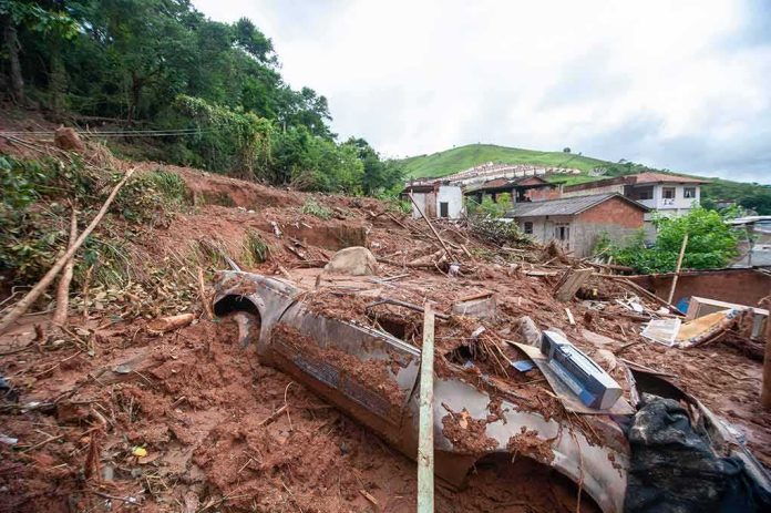
Chinese state media reported that a mudslide struck Gyirong Port, a primary border crossing between Tibet and Nepal, leaving at least three dead and 265 people missing by 8 p.m. on the day of the event. Those figures were described as initial tallies from local authorities—standard phrasing when access to the site is restricted and registries of workers, drivers, and travelers are still being reconciled. The port’s layout—a narrow valley corridor that concentrates warehouses, customs facilities, and vehicle queues—makes it acutely vulnerable to slope failures and debris flows that can sweep across the complex in seconds.
The early portrait from Chinese outlets emphasized a large-scale rescue mobilization, with emergency teams converging on the corridor and officials warning of “significant casualties” while they worked to reopen severed approaches. The specificity of the missing count reflects a bureaucratic reality: border sites maintain manifests and shift logs. When a slope fails into a logistics hub, those records become the starting point for search lists, even as investigators confirm who evacuated, who was off-site, and whose whereabouts remain unknown.
Why Early Numbers Are Provisional in the High Himalaya
Casualty figures in Himalayan disasters follow a familiar arc: an initial floor based on reachable ground truth, then revisions as rescuers carve into cut-off pockets and records are reconciled. This is not indecision; it is the geometry of terrain and the physics of debris-charged floods. When landslides and glacially fed surges collapse into narrow valleys, they shear away roads, bridges, and power simultaneously, isolating settlements and work sites. Wire services covering border-region catastrophes have, over years of events, described the same sequence—unreliable access, proliferating rumor, then a more complete tally as field verification catches up.
The Gyirong case fits that template. The border’s transshipment function draws truck convoys and warehouse crews into compact spaces beneath steep, fractured slopes—topography predisposed to failure under intense rainfall or upstream outburst conditions. Once roads are lost, helicopter access is constrained by weather and altitude, while ground teams face unstable debris and continuing rockfall. In this setting, a precise evening count can coexist with high uncertainty about individuals’ fates; the count is a ledger entry, not an endpoint.
The Border Hub and Its Physical Vulnerabilities
Gyirong Port sits where infrastructure funnels into a tight valley throat linking Tibet to Nepal’s Rasuwa District. Its modern role—customs processing, bonded storage, cross-docking of goods—puts heavy static loads and high traffic density on land at the base of slopes riddled with landslide scars. Debris flows in such corridors accelerate along engineered channels—drainage ditches, road prisms, retaining walls—until they overtop, redirect, and surge laterally into built areas. CCTV and eyewitness footage from recent transboundary events show how quickly these surges transition from channelized flow to sheet-like walls of mud, rock, and timber sweeping across plazas and ground floors. That dynamic explains why death and missing tallies in port complexes can be large even when the upstream event footprint is relatively localized.
A logistical node’s vulnerability is compounded by inventory and people co-locating: forklifts, stacked pallets, customs queues, and idling heavy trucks. Evacuation cues—ground vibration, unusual rumble, the first seep of turbid water—compete with routine industrial noise. In seconds, escape routes may be blocked by jack-knifed vehicles or collapsing sheds. Preparedness at such sites is therefore less about generic hazard awareness and more about rehearsed micro-evacuations: designated uphill refuges, pre-cleared stairwells, and automatic barriers that divert flow away from egress paths.
Mechanisms Behind Sudden Border Disasters
Multiple triggers can produce the kind of abrupt slope failure seen at Gyirong. Intense monsoon precipitation saturates colluvium and glacial till, elevating pore-water pressure until shear strength fails; rock-ice avalanches can entrain snow and debris into a destructive slurry; glacial lake outburst floods (GLOFs) can propagate high-energy pulses far downstream. In the last decade, Nepal–Tibet border events have included each mechanism, sometimes in sequence, with drainage of supraglacial lakes documented as the initiating cause in cross-border floods that turned deadly downstream. The common thread is rapid onset and poor warning lead time for communities and work sites built on alluvial fans and narrow benches.
Because the physical pathways are transboundary—rivers and valleys are indifferent to passports—monitoring gaps matter. A sensor or camera upstream on the Tibetan side, coupled with cross-border alert protocols, can translate minutes of early warning into hundreds of lives protected at a Nepali project site, and vice versa. This is where technical cooperation becomes less about diplomacy and more about plumbing: telemetry standards, power redundancy for remote stations, and unglamorous maintenance on silt-choked gauges that tend to fail just when they are most needed.
At least 95 people have been killed and more than 600 others are missing after a flash flood and mudslide along the Nepal-Tibet border washed away villages and damaged roads and infrastructure. pic.twitter.com/bsXNtfxJ58
— Did I Piss You Off? (@DIPYOMUCH) August 26, 2026
What Reliable Reporting Looks Like in This Terrain
Sober early reporting does two things: it anchors to named authorities for numbers, and it resists the temptation to generalize beyond what those authorities can actually see. In Gyirong, the clearest load-bearing fact remains the official tally—three dead, 265 missing—as of the first full operational period. Outlets that traced those counts to Xinhua and CCTV provided the necessary attribution while avoiding speculative escalations. Meanwhile, international desks framed the port as a locus of “major casualties,” a phrasing that is both accurate in context and appropriately cautious until site access expands.
The persistent challenge is time. Families and consulates want answers within hours; engineers and rescuers work inside a physics problem that yields them grudgingly. Past border-region emergencies demonstrate that overnight improvements in road access, coupled with a weather window for rotorcraft, can swing the arc from uncertainty to closure. Until then, the most responsible stance is precision: report the known, name the source, explain the constraints, and prepare the audience for revision as verification advances.
What This Means Going Forward
Two priorities emerge from Gyirong. First, infrastructure at border hubs must be designed for debris-flow recurrence, not merely historic averages—sacrificial berms, grade-raising of critical floors, and designated overflow channels that accept failure upstream but spare human concentration zones downstream. Second, the data-sharing spine across the Nepal–China frontier needs to be treated as critical infrastructure in its own right: interoperable alerts, mirrored data repositories, and joint drills that translate hazard telemetry into site-level action in minutes. These are not abstract reforms; they are directly responsive to the way people die—and survive—in valleys like Gyirong.
Sources:
aa.com.tr, wfsb.com, thestandard.com.hk, english.news.cn, news.sbs.co.kr, reuters.com